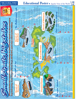
Small straits, big stakes
Just as our bodies rely on jugular veins to keep blood flowing, the global economy depends on a few waterways to keep trade moving. Aastha Narayan & Garvita Chugh, AIS MV, XII D, explore these critical maritime lifelines.
The world’s oil tap
Location: Between Iran and Oman, connecting the Persian Gulf with the Gulf of Oman and Arabian Sea.
Significance: A major chokepoint, it carries roughly 20 million barrels of oil and petroleum products daily.
Vulnerability (Extreme): At its narrowest, the 39-km-wide strait splits into 2 shipping lanes, each 3.7 km wide.
Historical footnote: The 1st-century Periplus of the Erythraean Sea is among the earliest texts documenting maritime trade in the region.
The Mediterranean’s gate
Location: Between Spain and Morocco, linking the Atlantic Ocean and the Mediterranean Sea.
Significance: A major shipping route and an important corridor for submarine fibre-optic cables.
Vulnerability (Extreme): Shipping accidents, anchor damage, and threats to undersea infrastructure can disrupt both physical and digital connectivity.
Historical footnote: Formed about 5.3 million years ago due to tectonic shifts that caused the ‘Zanclean Flood’, the largest mega flood in history.
The oceans’ shortcut
Location: Crosses the Isthmus of Panama, linking the Atlantic and Pacific Oceans.
Significance: A vital shortcut, it eliminates the need for ships to sail around South America.
Vulnerability (High): The canal depends on freshwater from Gatún Lake, making droughts and El Niño a major concern.
Historical footnote: Its name inspired the famous palindrome: 'A man, a plan, a canal, Panama!'
The gate of tears
Location: Between the Arabian Peninsula and the Horn of Africa, connecting Red Sea with Gulf of Aden.
Significance: A crucial route for container shipping and energy supplies between Europe, Asia & West Asia.
Vulnerability (Critical): Closure forces ships to go around Africa, surging fuel, insurance & freight costs.
Historical footnote: Its name means ‘Gate of Tears’, traditionally linked to an ancient legend of an earthquake that separated Arabia from Africa.
Asia’s shipping highway
Location: Between Sumatra & the Malay Peninsula.
Significance: One of the world’s busiest shipping routes and a key energy corridor connecting West Asia with East Asia.
Vulnerability (High): At its narrowest, the passage is only 2.8 km wide, increasing congestion, collision risks.
Historical footnote: The Srivijaya Empire of Southeast Asia controlled key parts of the strait in the 7th century, profiting from maritime trade.










 View Archives